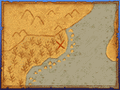
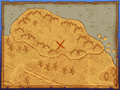
List of treasure map grotto locations in Dragon Quest IX
Jump to navigation
Jump to search
The following is a list showing all possible treasure map grotto locations in Dragon Quest IX. For a new treasure map, a grotto location is randomly chosen from the set of possible locations listed below.
-
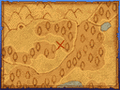
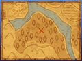
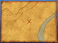
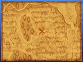
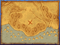
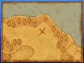
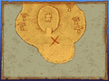
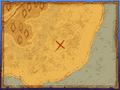
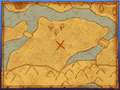
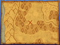
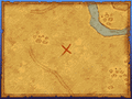
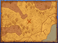
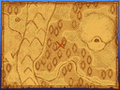
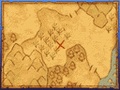
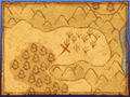
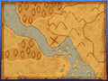
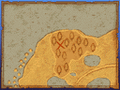
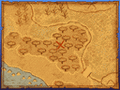
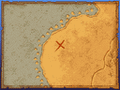
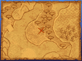
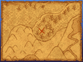
 Map of the Angel Falls region
 -
-
 Right outside Angel Falls
 -
 West of the Hexagon
 -
 Northeast of the Hexagon
 -
 Hill north of the Hexagon


-
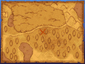
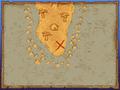
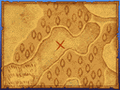
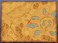
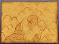
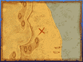
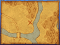
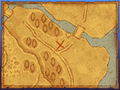
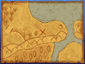
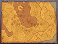
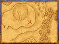
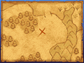
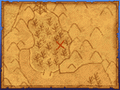
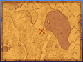
 Map of the Doomingale Forest region
 -
 Big poison lake west of Brigadoom
 -
 Small poison lake south of Brigadoom
 -
 East of Bringadoom


-
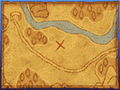
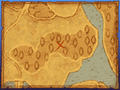
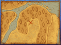
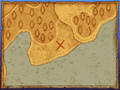
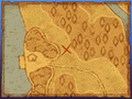
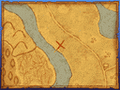
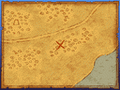
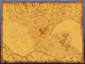
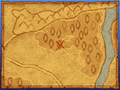
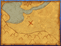
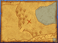
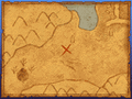
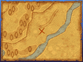
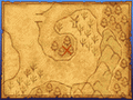
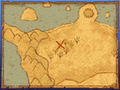
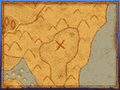
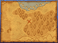
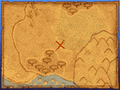
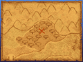
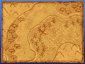
 Map of the Zere region
 -
 West of Zere
 -
 Southwest of Zere
 -
 Land south of Zere, reachable from the Stornway region
 -
 South east of Zere
 -
 Fields south of Zere


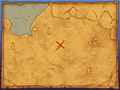
Western Stornway region
-
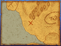
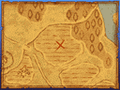
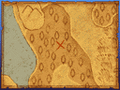
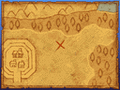
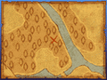
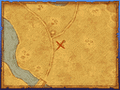
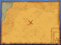
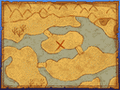
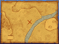
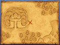
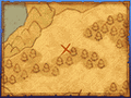
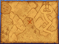
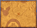
 Map of the Western Stornway region
 -
 Right next of Stornway
 -
 South of the bridge connecting with the Easter Stornway region
 -
 East of Stornway
 -
 Northeast of Stornway


Eastern Stornway region
-
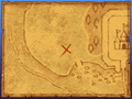
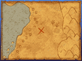
 Map of the Eastern Stornway region
 -
 South of the bridge connecting with the Western Stornway region
 -
 Beach at the middle of the region
 -
 South of the island
 -
 North of the island
 -
 North of the region


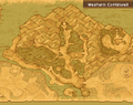
Eastern Coffinwell region
-
 Map of the Eastern Coffinwell region
 -
 Southwest of Coffinwell
 -
 South of Coffinwell
 -
 Southeast of Coffinwell
 -
 Southeast of Coffinwell
 -
 East of Coffinwell


Western Coffinwell region
-
 Map of the Western Coffinwell region
 -
 Forest southwest of the Quarantomb
 -
 West-most hill of the region
 -
 South of the Quarantomb
 -
 Small island south of the Quarantomb
 -
 Southeast if te¡he Quarantomb
 -
 South of the Tower of Nod
 -
 West of the Tower of Nod


-
 Map of the Newid Isle
 -
 West of Alltrades Abbey
 -
 South of Alltrades Abbey
 -
 North of Alltrades Abbey
 -
 West of Porth Llaffan
 -
 Northeast of Porth Llaffan
 -
 Western side of the High Plateau
 -
 Eastern side of the High Plateau


-
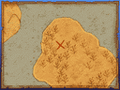
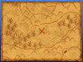
 Map of the Slurry Coast region
 -
 Right outside Slurry Quay
 -
 Beach south of Slurry Quay
 -
 South of Dourbridge


-
 Map of the Dourbridge region
 -
 South of Dourbridge
 -
 Northeast of Dourbridge
 -
 North of Dourbridge


-
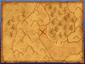
 Map of the Lonely Plains
 -
 Southwest of Zere Rocks
 -
 South of Zere Rocks
 -
 North of Zere Rocks


-
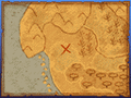
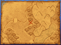
 Map of the Bloomingdale region
 -
 In front of the Lighthouse
 -
 South of Bloomingdale
 -
 East of Bloomingdale
 -
 East of Bloomingdale
 -
 East of the Bad Cave


-
 Map of the Lonely Coast
 -
 North of the plateau area
 -
 East of the plateau area
 -
 West of the plateau area
 -
 South western coastal area
 -
 South eastern coastal area
 -
 Eastern coastal area


-
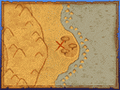
 Map of Pluvi Isle
 -
 On the island on the west


-
 Map of the Djust Desert
 -
 West of Gleeba
 -
 South of Gleeba
 -
 South of Gleeba
 -
 Southeast of Gleeba
 -
 Northwest of Gleeba0
 -
 Island on the east side
 -
 Island on the west side
 -
 Uhohasis (Elevated western area)


-
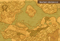
 Map of the Urdus Marshland
 -
 Westmost area of the region
 -
 West of the region
 -
 West-center of the region
 -
 Center of the region
 -
 Northeast of the region
 -
 North of the region
 -
 Northwest of the region


-
 Map of Hermany
 -
 West of the region
 -
 Southeast of the region
 -
 Island on the east side
 -
 East of the region
 -
 On the plateau


-
 Map of the Iluugazar Plains
 -
 North east of Batsureg
 -
 West of Batsureg
 -
 South of Batsureg
 -
 East of Batsureg
 -
 North of Batsureg


-
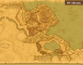 Map of Mt. Ulzuun
 -
 West of the lake
 -
 South of the lake
 -
 East of the lake
 -
 Northwest of the lake
 -
 South of Gerzuun
 -
 Southeast of Gerzuun
 -
 Southwest of Gerzuun


-
 Map of the Khaalag Coast
 -
 West of the region
 -
 East of the region
 -
 Center of the region


-
 Map of Mt. Ulbaruun
 -
 West of Baryaama's Graveyard
 -
 East of Baryaama's Graveyard
 -
 Northeast of Baryaama's Graveyard


-
 Map of Ondor Cliffs
 -
 On the plateau
 -
 North area of the coast
 -
 Central area of the coast
 -
 South area of the coast


-
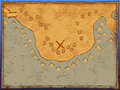
 Map of the Snowberian Coast
 -
 West of the region
 -
 Center of the region
 -
 North of the region
 -
 East side of the region
 -
 Northeast of the region


-
 Map of Snowberia
 -
 North west of Swinedimples Academy
 -
 West of Swinedimples Academy
 -
 West of Swinedimples Academy
 -
 Right next to Swinedimples Academy
 -
 Northeast of Swinedimples Academy


-
 Map of the Cringle Coast
 -
 East of the region
 -
 On the east of the island
 -
 North of the region
 -
 West of the region


-
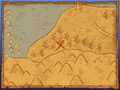
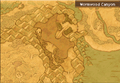 Map of the Wormwood Canyon
 -
 North of the canyon
 -
 South of the canyon


-
 Map of the Eastern Wormwood region
 -
 South of Wormwood Creek
 -
 East of Wormwood Creek
 -
 Plateau on the south east
 -
 Northeast of Wormwood Creek
 -
 North of Wormwood Creek


-
 Map of the Western Wormwood region
 -
 East of the Bowhole
 -
 On the small plateau
 -
 South of the Bowhole
 -
 East of the region
 -
 Center of the region
 -
 On the island


-
 Map of the Wyrmtail region
 -
 Northwest of the region
 -
 West of the region
 -
 East coast
 -
 Northern area of the region
 -
 Northern area of the region


-
 Map of the Wyrmwing region
 -
 Western beach
 -
 Center of the region
 -
 South of the region
 -
 Small plateau
 -
 East coast


-
 Map of the Wyrmneck region
 -
 Near the beach on the west side of the region
 -
 On the hill near the center of the region
 -
 On the northeast of the region


-
 Map of the Wyrmsmaw region
 -
 Right outside Upover
 -
 South of Upover
 -
 Northwest of Upover
 -
 Northwest area of the region


-
Map of the Gittish Empire region
-
 Next to the poison lake at the eastern side of the region
 -
 North of the Gittingham Palace


For more information regarding treasure maps, see Treasure map (Dragon Quest IX).
For a Chinese source, see the following location http://dq9.ffsky.cn/maplocation.htm